The Vltava River: History, Facts & Significance
The Vltava (German: Moldau) is the longest river in the Czech Republic at 430 km, rising from two headstreams in the Šumava (Bohemian Forest) mountains in southwestern Bohemia and flowing north through Český Krumlov, České Budějovice, and Prague before joining the Elbe (Labe) at Mělník, approximately 30 km north of the city. It drains approximately 28,090 square kilometres — more than half of Bohemia and about a third of the Czech Republic’s total area. The Vltava is commonly described as the Czech national river; it flows through Prague for 31 kilometres, is crossed by 18 bridges within the city, and has been the setting for the defining moments of Czech history for over a thousand years.
No river in Central Europe carries quite the same weight of national identity as the Vltava. It is the river that Prague was built around, the river that powered its medieval mills and carried its trade, the river that has flooded it and threatened it and been memorialised in its greatest music. Understanding the Vltava — its geography, its history, its cultural significance — is a way of understanding Prague itself.
The River: Basic Facts
The Vltava is 430 kilometres long and drains approximately 28,090 square kilometres — more than half of Bohemia. It rises from two headstreams in the Šumava mountains (Teplá Vltava and Studená Vltava), flows southeast then turns north through Bohemia, passing Český Krumlov, České Budějovice, and Prague, before joining the Elbe at Mělník. At its confluence with the Elbe, the Vltava actually carries more water than the Elbe itself, but joins at a right angle and is technically classified as a tributary.
This technical subordination of the larger river to the smaller one has a poetic quality that Czechs have long appreciated — the Vltava is in some sense the dominant presence, but yields its name at the confluence. The main tributaries of the Vltava are the Lužnice and Sázava rivers from the east and the Otava and Berounka from the west.
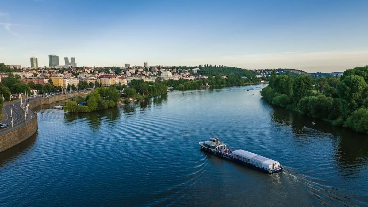
Within Prague, the river flows for 31 kilometres, is crossed by 18 bridges, and divides the city’s historic core into its principal districts: Malá Strana and Hradčany on the west bank, and the Old Town (Staré Město), New Town (Nové Město), and the Jewish Quarter (Josefov) on the east.
The Vltava Cascade: Nine Dams
The Vltava Cascade is a system of nine major dams and reservoirs built along the river primarily in the 20th century for hydroelectric power, flood control, water supply, and recreation. The two largest — Lipno (the largest body of water in the Czech Republic by area) and Orlík (the largest by water volume) — are in southern and central Bohemia respectively.
The Vltava Cascade transformed the character of the river along its upper and middle course. Where the river once ran through wild gorges and meadows, the reservoirs created large, calm bodies of water that became recreational areas. The castle at Orlík, perched on a rocky outcrop above the dam, was once a hilltop fortress; the rising waters when the dam was built in the 1960s submerged the valley below and turned it into a lakeside setting.
For those following the river from Prague upstream, the cascade gives the Vltava a dual character: the controlled, calm water of the reservoir system in Bohemia, and the fast, urban river that flows through the city.
Prague and the Vltava: A Historical Relationship
Prague was founded on the Vltava. The first settlements on the sites of both Prague Castle and Vyšehrad chose their locations precisely because of the river — the clifftop positions offered defensive advantages, and the river crossing below (at the location of the present Mánes Bridge) was one of the most important trade routes in Central Europe. The city that grew between and around these two fortified hills was, from the beginning, a river city.
The Vltava was the engine of Prague’s medieval economy. Its water powered the mills of Kampa Island — the chain of watermills along the Čertovka canal built by the Knights of Malta in the 12th century. The river carried trade from Bohemia’s interior to the north, and the tolls collected at Charles Bridge (the only river crossing for nearly 700 years) funded much of medieval Prague’s civic infrastructure.
The water from the Vltava was used as Prague’s drinking supply until 1912, when the Vinohrady Water Tower ceased pumping operations and the city transitioned to processed municipal water. The river ran through the daily life of the city in a way that is now difficult to imagine.
Flooding: The Vltava’s Other History
The Vltava has flooded Prague repeatedly throughout recorded history. High water marks on buildings near the embankment record the levels reached in 1784, 1845, 1890, 1940, and 2002. The 2002 flood — a 500-year event — was the most severe in Prague’s modern history. The water level reached 785 cm, more than 5,000 cubic metres per second flowed through the city, and the Charles Bridge was left seriously weakened, requiring years of repair work.
The pattern of major Vltava floods is irregular in an important way. Between 1890 and 2002 — a span of 112 years — there were no catastrophic floods. Five generations lived on the Prague embankment without experiencing the river at anything near its maximum capacity. Then in August 2002, two low-pressure weather systems carried warm, moist Mediterranean air over Central Europe and deposited precipitation across Bohemia at unprecedented rates. The Vltava rose to levels not seen in five centuries, inundating Karlín, parts of Malá Strana, and the Prague Zoo in Troja.
The human and material cost was significant. Seventeen people were killed across the Czech Republic; the financial damage ran to billions of euros. In response, Prague invested heavily in flood defences: permanent walls along vulnerable embankment sections, mobile barriers deployable in hours, and improved drainage systems. These measures were tested in 2013, when the Vltava flooded again — and the defences held.
Walking the Prague embankment today, visitors occasionally see high-water marks on old buildings — a shoulder-height plaque dated 14 August 2002 on a wall in Malá Strana being one of the more commonly noted. These marks record the Vltava’s most extreme expressions of its power, and serve as a reminder that the calm river running below the cruise boats has a different character in extreme years.
Smetana and the Vltava
Bedřich Smetana’s symphonic poem Vltava (1874) — the second movement of his cycle Má vlast (My Homeland) — is one of the most celebrated pieces of Czech classical music and one of the most vivid musical depictions of a river in the orchestral repertoire. The piece follows the river from its two mountain sources to Prague, past meadows, weddings, moonlit forests, and the ancient castle of Vyšehrad, before the river broadens and flows away to the north.
Smetana composed the piece while already profoundly deaf — a fact that makes its clarity and pictorial vividness all the more remarkable. The piece opens with two flute lines representing the Teplá and Studená Vltava headstreams, which combine into the main river theme. This theme — one of the most immediately recognisable in Czech music — builds and transforms as the river flows through different landscapes, eventually arriving at the broad, powerful current of the river through Prague beneath the Vyšehrad cliff.
The piece has taken on an almost official status as the musical embodiment of Czech national identity. It is played at significant national occasions, and the connection between the river and the music is so deeply embedded in Czech culture that for many, hearing the theme is inseparable from imagining the Vltava flowing through Prague.
Smetana is buried at Vyšehrad Cemetery, overlooking the river he celebrated. His museum — the Smetana Museum (Muzeum Bedřicha Smetany) — sits on a promontory directly beside Charles Bridge, right at the edge of the Vltava. The address, Novotného lávka 1, places it as close to the river as any building in the city.
The Vltava in Prague: A City Defined by Water
The relationship between Prague and the Vltava is not merely geographic. The river has shaped the city’s layout, economy, defence, mythology, and cultural identity at every stage of its development. The medieval trade crossing. The mill canal and Kampa Island. The defensive cliffs of Prague Castle and Vyšehrad. The embankment promenades built in the 19th century to reclaim the waterfront for civic life. The flood defences of the 21st century.
From the middle of the river on a cruise boat, all of this is present at once — the ancient bridges and the modern ones, the Gothic castle and the deconstructivist glass tower, the centuries of architecture compressed into a single navigable corridor. The Vltava is the context in which Prague makes sense.
Frequently Asked Questions
How long is the Vltava River?
430 kilometres from its headwaters in the Šumava (Bohemian Forest) mountains to its confluence with the Elbe at Mělník, approximately 30 km north of Prague.
What does Vltava mean in Czech?
The name derives from the old Germanic “Wilth-ahwa” meaning “wild water” or “wild river.” The German name for the river is Moldau — the name used internationally following Smetana’s famous symphonic poem.
Did the Vltava flood Prague in 2002?
Yes. The 2002 flood was a 500-year event — the most severe in Prague’s modern history. The water level reached 785 cm, with over 5,000 cubic metres per second flowing through the city. Seventeen people were killed in the Czech Republic and the financial damage ran to billions of euros. In response, Prague built permanent flood defences along vulnerable embankment sections.
What did Bedřich Smetana write about the Vltava?
Smetana composed the symphonic poem Vltava in 1874 as the second movement of his cycle Má vlast (My Homeland). The piece follows the river from its two mountain headstreams to Prague, passing meadows, weddings, moonlit forests, and Vyšehrad. He composed it while profoundly deaf. It is one of the most celebrated pieces of Czech classical music.
Does the Vltava flow through Prague Castle?
No — Prague Castle sits on the Hradčany ridge above Malá Strana, approximately 100 metres above and 400 metres west of the river. The Vltava flows below and beside the castle district, with the castle visible throughout most of the left-bank section of any standard river cruise.